Landslides in Wayanad, Kerala 2024
Introduction
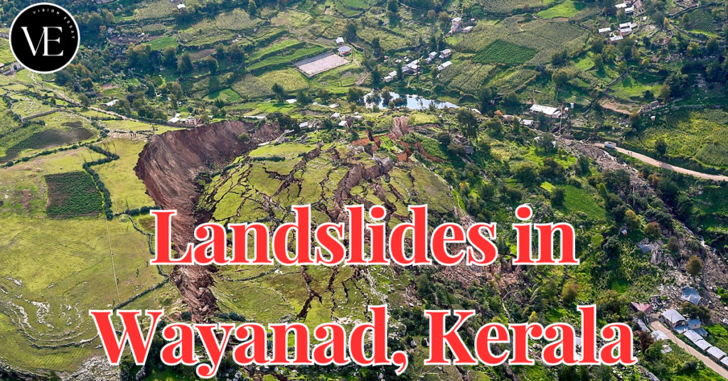
Due to heavy rains and delicate ecological circumstances, Kerala’s Wayanad region recently saw one of the worst landslides-related disasters. Exceeding forecasts and evoking memories of the disastrous 2018 floods that took around 500 lives, the district got almost 140 mm of rain in a single day.
What are Landslides?
- Rock, dirt, and other material sliding down a hill on a small-to-large scale is a devastating occurrence known as a landslide.
- It can happen on slopes that are naturally occurring or created by humans, and things like heavy rain, earthquakes, volcanic activity, groundwater level fluctuations, and human activity bring it on.
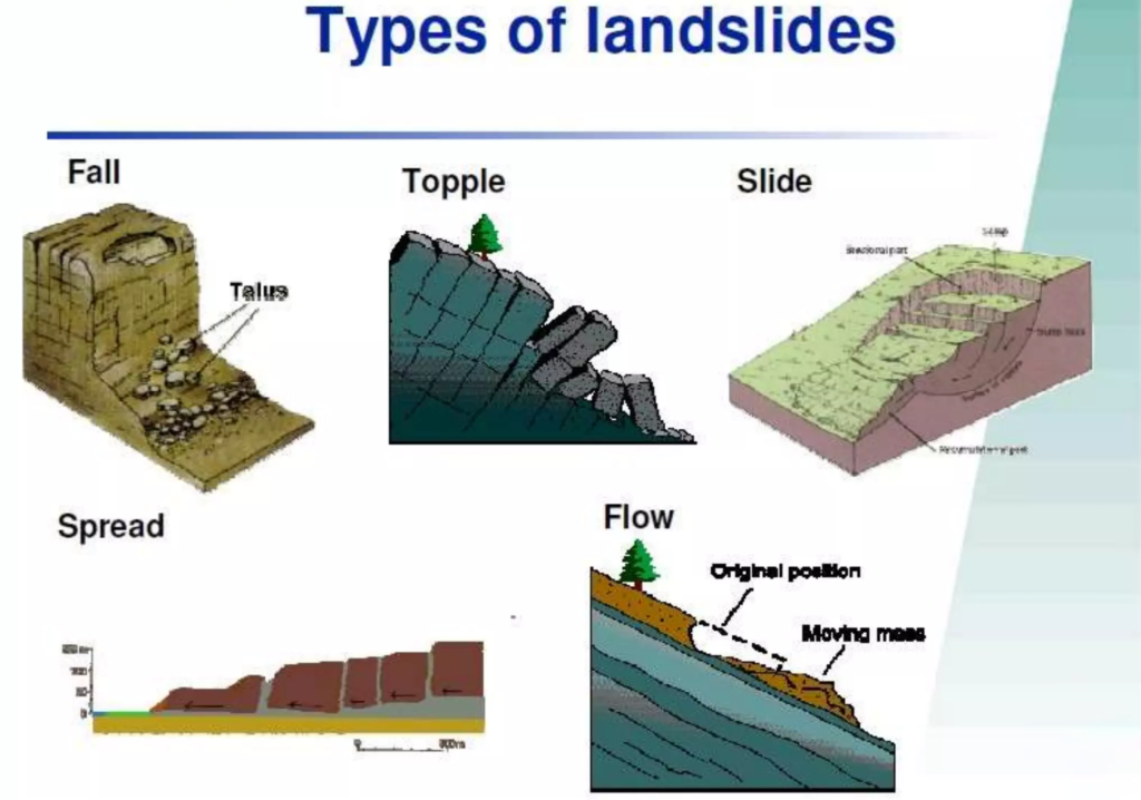
What are the Types of Landslides?
- Slides: Rotational and translational movement along a surface of rupture.
- Flows: Rock or dirt combined with water that moves fluidly; examples include creep, mudflows, debris flows, and earth flows.
- Spreads: Lateral mass extension and fracture, frequently brought on by liquefaction.
- Topples: Revolving forward and falling freely from a near-vertical or vertical incline.
- Falls: Slipping from a cliff or steep slope and falling, rolling, or bouncing.

What is the Landslides Atlas of India by ISRO?
- India is one of the top 5 nations in the world for landslides.
- Switzerland, Italy, the US, and China are the others.
- About 0.42 million sq. km., or 12.6% of India’s total land area, is vulnerable to landslide hazards.
- The distribution of landslides reported in India is as follows:
- In the Northwestern Himalayas, 66.5%
- In the Himalayas of the Northeast, 18.8%
- In the Western Ghats, 14.7%
- According to the Geological Survey of India, in many developing nations, the economic damage caused by landslides can reach 1% to 2% of the GDP.
What are the major landslide-prone areas in India?
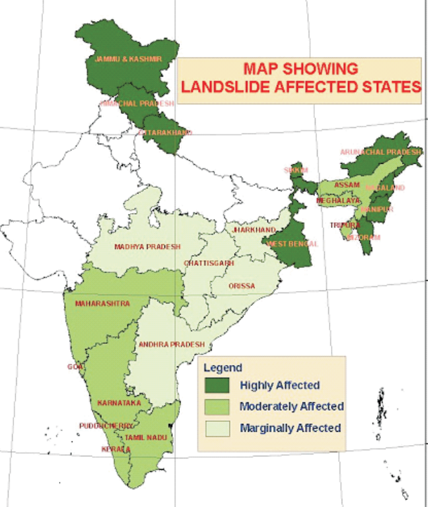
- The Northeastern Locale incorporates Jammu & Kashmir, Uttarakhand, and Himachal Pradesh along the Himalayas, making up almost 50% of all landslide-prone areas.
- Along the Western Ghats are Maharashtra, Goa, Karnataka, Kerala, and Tamil Nadu.
- The eastern Ghats of Andhra Pradesh are home to the Araku area.
- Landslides are predicted to occur in around 17,000 sq km in Kerala, primarily on the western side of the Western Ghats.

What are the Causes of Landslides?
- Gravitational Forces
- They draw materials downslope continuously, which is the main cause of landslides.
- Rocks, sand, residue, and clay are illustrations of geomaterials whose shear quality is surpassed by gravity. This failure of the slope causes the materials to slide downward.
- Natural Triggers
Rainfall:Prolonged or heavy downpours raise the water content of the soil, which weakens slopes’ cohesiveness and adds weight to them, increasing the likelihood of failure.Earthquakes:Particularly in tectonically active areas like the Himalayas, earthquakes destabilize slopes by trembling the ground and compromising the structural integrity of geomaterials.Erosion:The steadiness of inclines can be compromised by normal forms that dissolve their base, such as a stream or wave development. Because of the disintegration caused by waves, coastal areas are particularly defenseless to avalanches.
- Hydrological Factors: The danger of landslides can be influenced by groundwater movement. Because water may infiltrate through porous materials, the slope can become weaker because it increases pore pressure and decreases effective stress.
- Anthropogenic Influences
Deforestation:By removing tree roots that naturally strengthen slopes and facilitate water drainage, vegetation has been destroyed, causing slopes to become unstable.Building and Land Use Changes:By interfering with natural drainage and load distribution, mining, road building, and urban growth have increased the danger of landslides.Infrastructure Development:The creation of artificial lakes, resorts, and other infrastructure has increased land pressure and disturbed natural drainage, raising the danger of landslides.
- Geological Factors: Slope stability is greatly impacted by geological characteristics, such as the makeup, structure, and degree of weathering of the materials.
- Defunct Quarries: The existence of quarries in the region, even after they have stopped operations, has also contributed to soil destabilization since the geological structure may be weakened by the vibrations and shockwaves from these activities, leaving the area more vulnerable to landslides during periods of high rainfall.
What are the Challenges Associated with Landslides?
- Death and Serious Injury: People living in impacted regions may experience fatalities and severe injuries as a result of landslides. Because landslides occur suddenly, there is frequently limited time for evacuation.
- Displacement of Communities: Landslides have the potential to force communities to migrate due to population displacement. This may cause societal systems to collapse and result in persistent socioeconomic problems.
- Infrastructure Damage: Serious damage or destruction of vital infrastructure, including buildings, bridges, and highways, can result in large financial losses and make rescue and relief efforts more difficult.
- Economic Impact: Humanitarian relief and infrastructure rehabilitation may be expensive endeavors. Landslides can also cause economic disruption in the area, especially in places where agriculture and tourism are major industries.
- Environmental Degradation: Soil erosion, vegetation loss, and habitat damage caused by landslides can harm ecosystem services and biodiversity.
Why is Predicting Landslides Difficult?
- Complexity of Geomaterials: It is challenging to determine stability precisely because the subsurface is made up of a variety of rocks and particulate materials with varying strengths.
- Lack of Data: Extensive three-dimensional mapping of geomaterials is necessary, but the technology available today frequently depends on scant data from a small number of sites, which breeds doubt.
- Finding Weak Areas: Prediction errors can arise from the easy overlooking of critical weak areas, such as fissures in rock masses.
- Estimating magnitude and Runout: Risk evaluations are made more difficult by the difficulty of precisely estimating the magnitude of a prospective landslide and its runout distance.
- Timing Predictions: Landslide timing is unpredictable, much like weather or seismic activity forecasting, which makes it challenging to estimate when they will happen.
- Environmental Variability: Predictions get much more difficult when variations in rainfall patterns, seismic activity, and human activity all affect slope stability.
- Technological Restrictions: Particularly in isolated or inaccessible locations, existing sensors and models might not be able to give the required accuracy for precise forecasts.
What are the Government Initiatives to Mitigate Landslide Risks in India?
- National Landslide Risk Management Strategy (2019): This all-encompassing approach covers mapping hazards, tracking them, implementing early warning systems, raising public awareness, developing capacity, creating regulations, and taking stabilization actions.
- Landslide Risk Mitigation Scheme (LRMS): This program, which is currently in the planning stages, intends to offer financial support for specially designed landslide mitigation initiatives in states that are at risk of them. It will concentrate on disaster prevention, mitigation techniques, and research and development for essential landslide monitoring.
- Flood Risk Mitigation Scheme (FRMS): A plan to create digital elevation maps, early warning systems tailored to each river basin, and flood shelters for flood preparedness and evacuation.
- National Guidelines on Landslides and Snow Avalanches: The National Disaster Management Authority (NDMA) has guidelines that address risk management, institutional procedures, financial arrangements, hazard assessment, structural and non-structural interventions, and community involvement.
- Landslide Atlas of India: It is an extensive website that records instances of landslides in the nation’s susceptible regions and offers damage evaluations for specific locations. It provides crucial data and insights about landslides in India and was created by the National Remote Sensing Centre (NRSC) of the Indian Space Research Organization (ISRO).
What Measures Can Be Taken to Prevent Landslide Hazards?
- Harnessing Technology for Vigilant Monitoring: To monitor sensitive regions, particularly heavily inhabited and urbanized zones, make use of web-based sensors such as rain gauges, piezometers, inclinometers, extensometers, InSAR (Interferometric Synthetic Aperture Radar), and total stations.
- Integrated EWS: Create a thorough emergency response system (EWS) by utilizing machine learning (ML) and artificial intelligence (AI) algorithms to forecast and notify communities of approaching risks. This will give them ample time to take preventative action.
- Sustainable Socio-Economic Progress: Acknowledge the importance of the area’s natural resources for sustainable socioeconomic development, including minerals, energy supplies, glaciers, springs, and medicinal plants. For long-term sustainability, strike a balance between ecological preservation and resource use.
- Building Codes and Evaluation: Mapping towns and determining load-bearing capabilities are necessary to create strong building rules that ensure safe development in places prone to hazards. To stop activities that might cause the soil to become unstable, impose stringent land use restrictions in certain regions.
Conclusion
The interaction between natural calamities and human activity is starkly illustrated by the Wayanad landslides. It will need a multipronged strategy including scientific study, education, and legislation to reduce the hazards and safeguard vulnerable people in the future.
Frequently Asked Questions(FAQs)
What are the main causes of landslides in Wayanad?
The main causes of landslides in Wayanad include heavy rainfall, deforestation, and construction activities that destabilize slopes and weaken soil structure.
How can we mitigate the impact of landslides?
Mitigating the impact of landslides involves implementing sustainable land-use practices, reforestation, and developing early warning systems to alert communities of potential risks.
What role does climate change play in increasing landslide risk?
Climate change contributes to increasing landslide risk by causing more intense and unpredictable weather events, such as heavy rainfall and storms, which trigger landslides.
What are the long-term effects of landslides on the environment?
Landslides can have long-term effects on the environment, including soil degradation, loss of vegetation, and changes in landforms, which can impact biodiversity and ecosystem stability.
Sources:
- https://www.thehindu.com/news/national/kerala/wayanad-landslides-official-death-toll-at-222-search-and-rescue-operations-enter-seventh-day/article68487470.ece
- https://www.newindianexpress.com/states/kerala/2024/Aug/04/wayanad-landslides-rescue-operations-enter-day-six-as-death-toll-crosses-360
- https://en.wikipedia.org/wiki/2024_Wayanad_landslides

Leave a Reply